02/07/2024, 9:33 am EST

Much-needed Incoming Rains for Argentina

There is good news in the forecast for Argentina. A stalled Madden Julian oscillation (MJO) in the central tropical Pacific Ocean has an influence on South America climate that increases vertical motion (convective clouds/thunderstorms).
02/07/2024, 5:04 am EST

Brazil and Middle East Drought to Worsen, Southeast Asia/Indonesia Reverse Wetter Ahead

Strengthening drought was observed during NOV/DEC/JAN 2023-24 in Central Brazil, Northwest Africa, the Middle East, and Central Indonesia. El Nino 2023-24 has shifted past the mature stage. The outlook is for rapid deceleration to neutral ENSO during MAR/APR/MAY 2024. Drought concern is highest across Central Brazil to Chile, the Middle East, and South Africa. A climate pattern change to a wetter scenario is projected for Southeast Asia and Indonesia.
02/06/2024, 2:29 pm EST

Most Negative Daily Southern Oscillation Index of El Nino 2023-24 Spawns California “Bomb Cyclone”

The convection phase of the Madden Julian oscillation (MJO) shifted to near and east of the Dateline in recent days intensifying moving across warm El Nino waters. The event caused southern oscillation index (SOI) to dip to the most El Nino-like signature of the 2023-24 episode. The MJO event and attendant strengthening EL Nino climate caused the California "bomb cyclone" of Feb. 4-5, 2024.
02/06/2024, 8:26 am EST

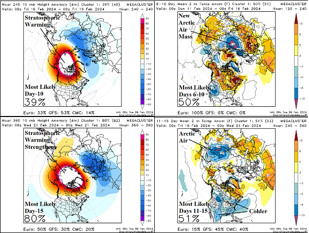
Colder Pattern Change U.S. But Arctic Air In-Doubt For Now

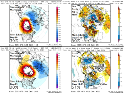
The day-10 temperature anomaly forecast at 10 MB reveals a stratospheric warming episode over northwestern North America. The warming causes an arctic air mass to develop over Northwest Russia in the 6-10-day period. On day-15, the stratospheric warming is widening and, frankly, looks scary as widespread arctic air is normally produced by this signature. However, for now, the “most likely” scenario is arctic air moves east across Eurasia and is shifting southeastward toward China much like the outbreak in December.
02/05/2024, 5:56 am EST

South America Drought is Worsening Especially in Argentina

Late summer 2023-24 drought in South America is worsening. Most recently, Argentina has received very little rain while anomalous heat has accelerated drying of soils. This effect has also affected Southern and Northwestern Brazil.
02/05/2024, 5:55 am EST

Colder U.S. Pattern Change Ahead; Arctic Air Adheres to Snow Cover

Forecast models generally doubt a major arctic outbreak into the U.S. ahead. The coldest possibility is presented by the mega-cluster ensemble rating widespread cold in 15 days (Feb. 20) at 23% risk. The most likely scenario, given the evidence available, is sharp cold risk to areas with snow cover near the U.S./Canada border east of the Continental Divide. Cold weather traveling south of where snow cover is located is brief and will moderate.
02/04/2024, 9:31 am EST

Updating The -AO/-EPO Forecast for After Mid-February; Will Arctic Air Return to North America?

Around February 17-18, temperatures are forecast to plummet to -40F to -50F in Siberia to Mongolia as rapid onset of an arctic air mass develops in response to stratospheric warming stretching from Siberia to the polar region and northwestern North America. Stratospheric warming enhances an evolving negative arctic oscillation (-AO) beginning later this week followed by emergence of a moderate to strong negative East Pacific oscillation (-EPO).
02/02/2024, 9:37 am EST

Argentina Dryness Becoming Severe

Severe dryness and anomalous heat have shifted over Argentina the past 7-10 days. The 7-day percent of normal rainfall observations across South America reveal little or no rain across much of Argentina and Chile. The Argentina dryness is accompanied by anomalous heat accelerating the drying of soil moisture conditions.
02/02/2024, 8:24 am EST

Another Stratospheric Warning Event Generating Arctic Air Mid-February?

A potential third stratospheric warming event forecast for the middle third of February over Siberia to northwestern North America could spawn another arctic air mass. If the attendant negative arctic oscillation (-AO) is accompanied by negative East Pacific oscillation (-EPO) a North America polar vortex pattern could emerge especially if AO and EPO are in the -1.5 range as indicated for mid-month.
02/01/2024, 9:14 am EST

Equatorial Pacific Upper Ocean Heat Plummeting

During January 2024, upper ocean heat across the equatorial Pacific Ocean plummeted. The Pacific basin upper ocean heat anomaly has slipped below the El Nino threshold.
02/01/2024, 5:30 am EST

Consistent Forecast: Europe Turns Wintery Cold Again Mid-February

Persistent upper trough across Northwest Eurasia during winter 2023-24 shifts to Central Europe. Gradually, Northern Europe chill shifts farther south. The upper trough triggers a significant storm track across Southern Europe through the Black Sea region with increasing risk of snow.