12/17/2023, 12:17 pm EST

Why Is Eastern Australia Wet During The 2023 El Nino?

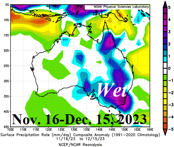
Early meteorological summer is usually drier than normal across Eastern Australia when El Nino is present. However, the past 30 days have featured robust wet anomalies across the eastern third of the continent in contrast with very dry weather of the last 3 El Nino years for the same period in 2015, 2009, and 2002. Rainfall forecasts through the remainder of December maintain the very wet East Australia pattern. Why is the unexpected rainfall occurring?
12/14/2023, 2:10 pm EST

El Nino High Wind/Heavy Rain Event East U.S. SUN/MON

The upcoming storm for late weekend into early next week on the East Coast is an El Nino storm. Problems: 1.) Develops at a low latitude over very warm water therefore unusually low pressure (980-985 MB off Mid-Atlantic Coast) emerges; 2.) Unusually low pressure running into a high-pressure area southeast of Canada will create hurricane force wind gusts northeast and east of the storm center possibly affecting southern New England and Long Island; 3.) Because the storm was born over warm water, an unusual heavy rain is likely for the Northeast Corridor.
12/14/2023, 9:14 am EST

Brazil Drought Concerns; Wet Bias is Stronger with Medium-range Forecasts

As meteorological summer unfolds, concern regarding Brazilian drought is ongoing. One steady development in recent weeks is the tendency for forecast models to over-forecast rainfall in the medium-range particularly in the 11-15-day period. During the past 7 days, the wet bias has increased.
12/13/2023, 12:54 pm EST

Focus on Brazil Drought

The rainfall pattern during the past 30 days is very wet in Southeast Brail/Northeast Argentina and Western Brazil while most of the remaining sections of Brazil are dry. The influence of this regime plus the longer-term climate is to produce deep (10-200 CM) soil moisture anomaly deficits across Northern Brazil, Southwest Brazil, and Interior East Brazil.
12/12/2023, 8:08 pm EST

Strong Positive Reflective Index Next Week Supports Major Pattern Change in North America in January

Strong opposing cross-polar 10 MB height anomalies as forecast by GFS in 10 days are characteristic of strong +RI events. Based on the research, what can follow in 2-3 weeks is a shift in the troposphere of a mild 500 MB ridge pattern over North America (as forecast for the next 1-2 weeks) to shift northwestward forming a ridge bridge pattern over Alaska.
12/12/2023, 6:58 am EST

Prohibitive U.S. Warmth Ahead of January Pattern Change

ECM “weeklies” indicate development of a stormy and cold upper trough in the Central/East U.S. as the middle third of January arrives. Climate Impact Company constructed analog climate forecasts support this projection. Recent positive phase reflection index also supports this potential pattern change.
12/12/2023, 6:44 am EST

El Nino to La Nina in 2024, What to Expect for DEC/JAN/FEB 2024-25

Of interest, is the reasonable certainty by many dynamic and statistical ENSO phase forecast models that La Nina will replace the current El Nino during the last third of 2024. Consequently, a brief glimpse as to what to expect for winter 2024-25 temperature patterns in North America and Europe plus rainfall patterns for summer 2024-25 in South America and Australia is reviewed.
12/11/2023, 3:09 pm EST

Today’s El Nino East Coast Storm

In the East, a departing El Nino storm continues to raise havoc over the Northeast Corridor featuring ongoing flooding rains in southern and eastern New England where high wind is also occurring leading to patchy power outages.
12/10/2023, 6:45 am EST

November 2023 U.S. Temperature/Precipitation Rankings

November 2023 ranked 19th warmest on record given the 129-year climatology. New Mexico and Nebraska ranked MUCH ABOVE normal temperature while the remainder of the West and Central States were warmer than normal. The South and East U.S. were close to normal.