News
02/18/2026, 8:47 am EST

Aerial Coverage of Great Lakes Ice and FEB/MAR/APR Temperature

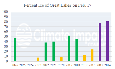
As of February 17th, the aerial coverage of ice across the Great Lakes is 47%. Since 2014, the current aerial coverage of Great Lakes ice is about average. When Great Lakes ice has been above average as observed during the 2013-14/2014-15 polar vortex winter seasons, FEB/MAR/APR climate across North America was biased colder than normal. When ice is at moderate levels similar with 2026, a cold bias during FEB/MAR/APR appears to the west of the Great Lakes region
02/17/2026, 8:36 am EST

Widening/Intensifying Australia Rainfall

The Australia outlook is prohibitively wet for most of the continent. AI models are utilized although dynamic models are agreeable to possible extreme rainfall centered on East-central to South-central Australia over the next 15 days. No change in the 16-20-day forecast as the wet regime continues.
02/16/2026, 12:02 pm EST

U.S. Weather Pattern Features Significant Increase in Hazards

The U.S. weather pattern shifts to problematic with a large array of hazards focused on the western half of the U.S. Featured are widespread wind and snow advisories/watch/warnings including a Red Flag Warning across much of the western Great Plains. Widespread dense fog stretches from Dallas to Cleveland. An offshore storm brings high wind near the Northeast U.S. Corridor.