News
10/05/2025, 1:27 pm EDT
A graph showing the number of negatives AI-generated content may be incorrect.

Evolving -NAO Pattern Could Cool East U.S. in Extended-range

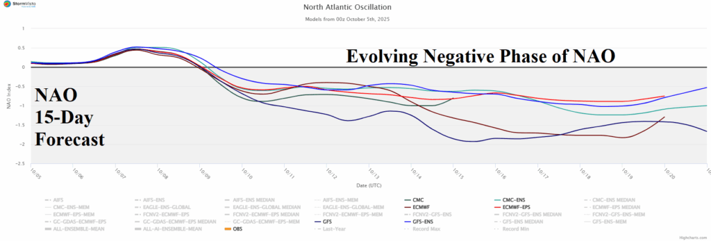
The latest North Atlantic oscillation (NAO) 15-day forecast reveals an evolving moderate-to-strong negative phase usually causal to a blocking high pressure over Greenland and a compensating upper trough into the Northeast U.S. Forecast models have resisted that forecast solution over the weekend, however, at 12Z today, the GFS follows the -NAO guide.
10/05/2025, 10:04 am EDT
A map of the weather AI-generated content may be incorrect.

Most, Not All, Brazil Soybean Areas Are Wetter

Departing September, GRACE-based soil moisture anomalies analysis reveals improving conditions in the central/east-central Brazil soybean-growing areas while harsh drought in the southern soybean-growing areas receives beneficial rainfall in the latest 15-day outlook. The far eastern soybean growing-areas remain in drought with a dry outlook during the next 15 days.
10/02/2025, 4:43 am EDT
A map of australia with different colored spots AI-generated content may be incorrect.

Borderline La Nina/-IOD Pattern Under-performing as Rainmakers in Australia

Negative Indian Ocean dipole (-IOD) contributes to Central and East Australia rainfall during winter and spring while La Nina biases eastern continent wet. Both climate signals emphasize a wet bias to Australia climate and diminish dry risk. The -IOD regime is well established while borderline weak La Nina is present but without a clear atmospheric response. Consequently, the anticipated wet climate for early spring is patchy, based on September rainfall terciles. Note the dryness in key Australia crop areas in Victoria and eastward.
10/01/2025, 6:58 am EDT
A graph showing the difference between the average and the average AI-generated content may be incorrect.

U.S. Winter Gas Population Weight HDD Biased Mostly Warm

Since last month, it’s getting more difficult to make the case for significant cold this winter season. The November forecast edges warmer, and DEC/JAN is already warm. FEB cold risk remains but confidence is lower. MAR chill remains in the forecast. Forecast models are warm. Mid-latitude oceans are warm. The orientation of mid-latitude SSTA supporting cold weather in North America this winter season showed potential one month ago but are eroding since that time.