10/20/2025, 7:28 pm EDT
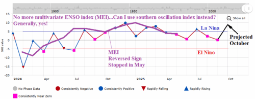
NOAA’s multivariate ENSO index (MEI) changed its data input from the Japanese Meteorological Agency’s JRA-55 reanalysis dataset to JRA-3Q as of January 2024. However, the data has not been attainable since May although NOAA claims the data is available (although hard to decipher with the government shutdown). MEI is a handy climate diagnostic identifying the atmospheric reaction to the SSTA/SLPA pattern across the Pacific tropics/subtropics.
