07/24/2025, 5:23 am EDT
A map of the world with different colors AI-generated content may be incorrect.

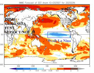
July 2025 ENSO Outlook: Making the case for weak La Nina in quarter 4/2025.

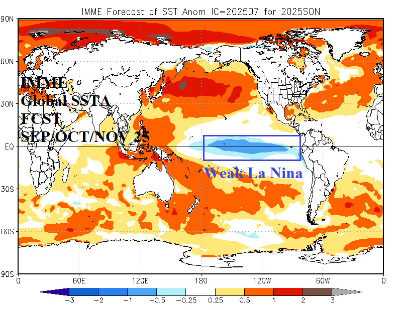
Some forecast models have insisted that weak La Nina redevelops by quarter 4/2025. Diagnostics confirm the La Nina potential. During recent weeks a traditional cool phase Pacific decadal oscillation has formed, and the attendant atmospheric wind is driving cool waters off the U.S. West Coast toward the tropics south and southwest of Hawaii. Upper ocean heat has suddenly cooled. If the current trend persists, weak La Nina could emerge by northern hemisphere mid-autumn.
07/23/2025, 12:38 pm EDT
A map of the sea AI-generated content may be incorrect.

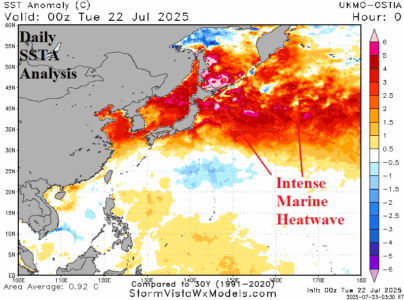
Marine Heatwave Inspires China to Japan Extreme Heat

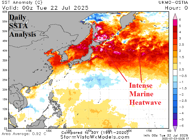
Reported early today is a record number of high temperature days since March in China (Al Jazeera). Most recently, excessive heat has been observed across East-central China where temperature anomalies of +2C to +6C were observed July 16-22, 2025.
07/22/2025, 4:49 am EDT
A map of the world AI-generated content may be incorrect.

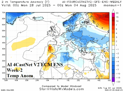
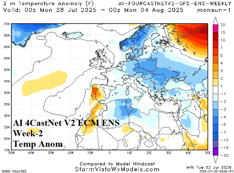
Eastern Europe to The Black Sea Region Shifts Wetter/Cooler

AI 4Cast Net V2 ECM ENS is used operationally due to the much higher skill score compared to traditional operational models during the past 30 days. The outlook is considerably cooler across Eastern Europe where a wet pattern resides. Wet and cool weather extends to the Black Sea region.
07/21/2025, 1:36 pm EDT
A map of a weather forecast AI-generated content may be incorrect.

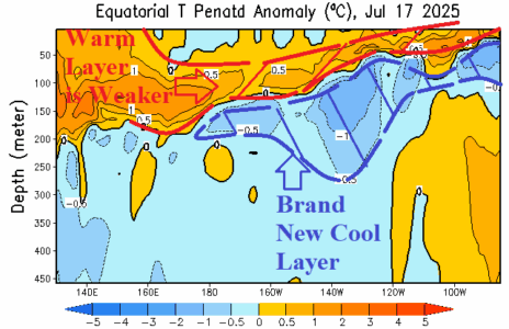
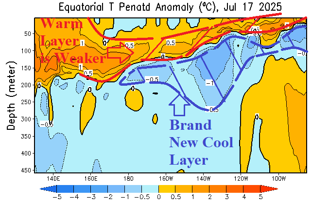
Subsurface Equatorial East Pacific Showing Signs of Cooling

The upper ocean temperature anomaly structure in the eastern equatorial Pacific indicates a new moderately deep cool layer. The warm layer just beneath the surface is beginning to weaken. The long-term ENSO outlook for later in 2025 remains in the neutral phase. However, as observed all of 2025, some models are indicating La Nina development, and a slight cooler trend has developed supportive of the La Nina outlier forecasts.
07/20/2025, 12:16 pm EDT
A map of the united states with different colored lines AI-generated content may be incorrect.

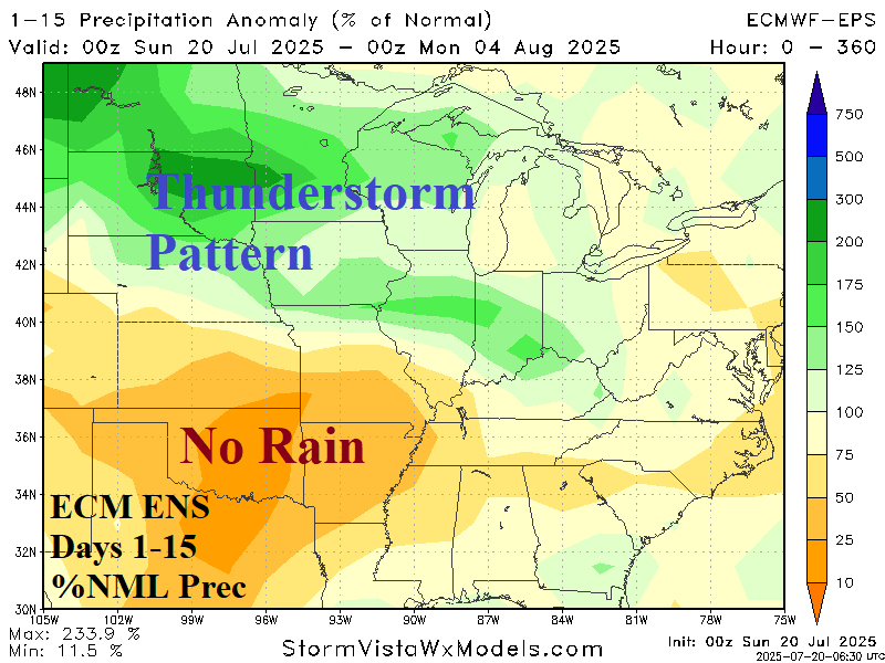
U.S. Crop Areas Hit By Heavy Rain Vs. Extreme Heat

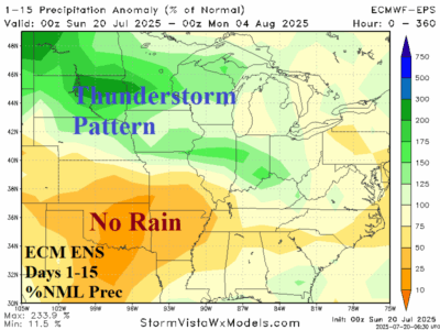
The 2-week outlook across the U.S. features harsh high impact weather including a stretch of heavy rain, severe thunderstorms, and local flooding from the Southern Canadian Prairies across the North-Central U.S. and through the Midwest States.
07/20/2025, 9:30 am EDT

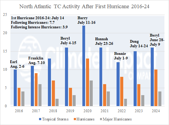
First North Atlantic Hurricanes 2016-24 and Following Activity

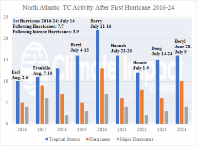
The Operational GFS and ECM forecast models are not projecting hurricane threats through their 15-day forecast period which brings us to August 4th without a hurricane so far during the 2025 season. Since 2018, the season’s first hurricane occurred prior to August 1st and during the 2016-24 active period (seasonal activity about 30% higher than the 30-year normal) the average date of the first hurricane is July 14th.
07/18/2025, 5:44 am EDT
A graph of a temperature forecast AI-generated content may be incorrect.

Comparing Best Dynamic and Machine Learning Forecast Models for Australia Outlook

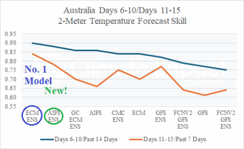
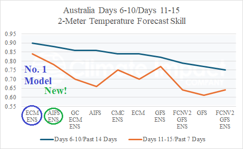
On July 1st, the Artificial Intelligence Forecast System Ensemble (AIFS ENS) was introduced. So far, AIFS ENS is second-best forecasting 2-meter temperature across Australia for both the 6-10-day and 11-15-day periods. ECM ENS is number 1! The ECM ENS is routinely at the top for the past 1 year of the evaluations shown for most parts of the world including North America and Europe. The AIFS ENS debut is impressive, challenging ECM ENS at the top.
07/17/2025, 12:40 pm EDT
A screen shot of a graph AI-generated content may be incorrect.

Suddenly, Nino34 SSTA is Cooling. Some Models Forecast La Nina Ahead

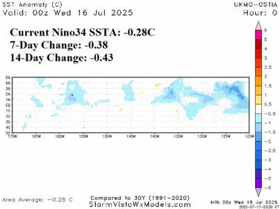
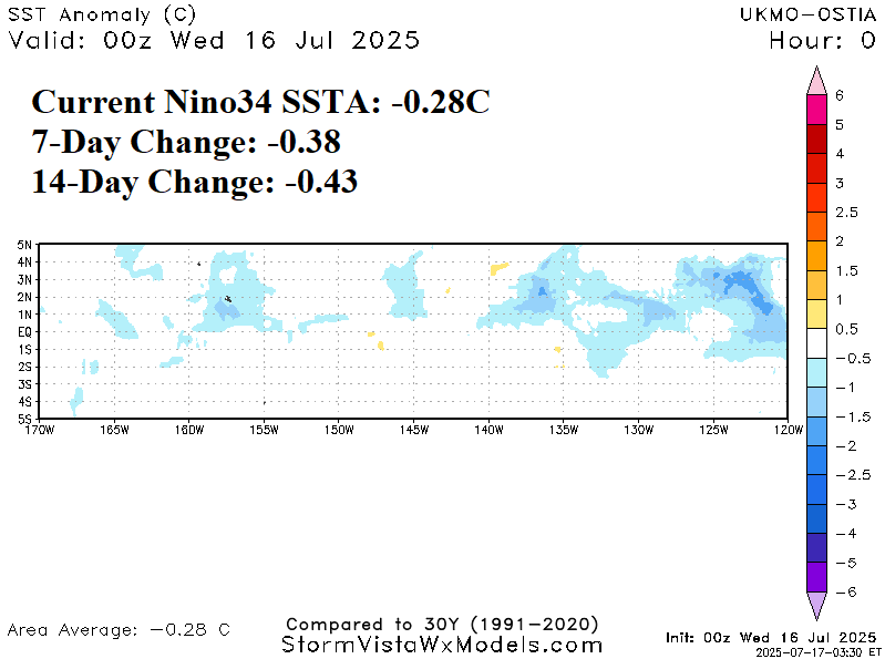
During the past 1-2 weeks, the Nino34 SSTA has cooled by more than 0.4C to -0.28C in the latest daily analysis. The La Nina threshold is -0.5C. Running parallel (and possibly related) to the Nino34 SSTA cooling is the vivid cool SSTA off the U.S. West Coast with that cooler water riding the California Ocean Current south and southwestward toward the tropics.
07/17/2025, 9:18 am EDT
A map of the united states with different colored areas AI-generated content may be incorrect.

New NOAA Long-lead Climate Forecasts Implicate Southeast U.S. for Tropical Cyclone Risk

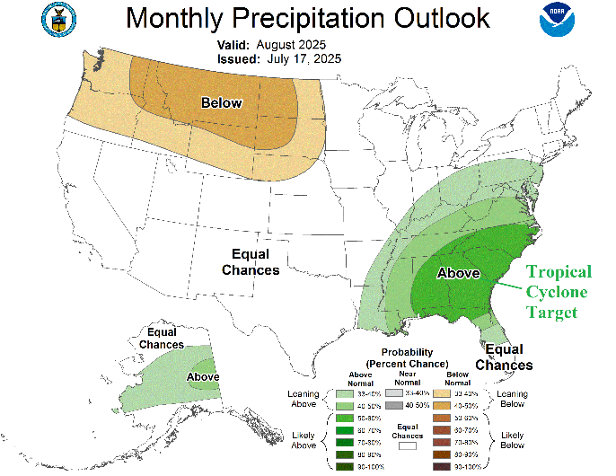
NOAA/CPC has updated their monthly long-lead probabilistic temperature and precipitation forecasts. Additionally, a new Seasonal Drought Forecast is issued. Of note, is the precipitation outlook for both August and AUG/SEP/OCT. The outlooks indicate a high probability of above normal rainfall in the Southeast U.S. The August probability forecast for above normal rainfall in the Southeast U.S. is exceptionally confident.
07/17/2025, 6:04 am EDT
A graph of a number of people AI-generated content may be incorrect.

Midwest/Central U.S. Heat Wave!

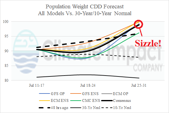
93L moves inland over Louisiana today unloading 3-6 inches of rain across the coastal region. A Flood Watch covers the entire southern half of Louisiana. The latent heat release of the stagnant convection over the next 2-3 days is released into the middle atmosphere to the north and forces a high-pressure area to build. The high pressure expands westward while continuing to strengthen causing a late July massive heatwave!
07/15/2025, 4:59 am EDT
A map of the united states AI-generated content may be incorrect.

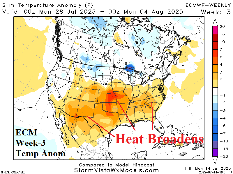
Issuing Heat Alert for Central/South-central U.S. Late July

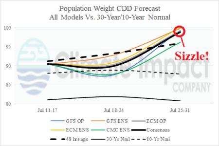
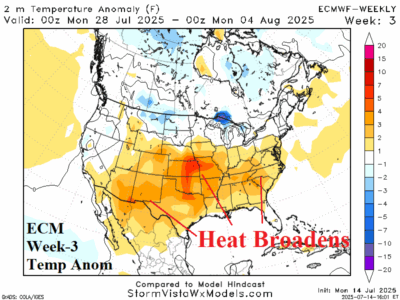
Intense heat featuring widespread risk of >100F is indicated for the southern ½ to 2/3 of the U.S. into early August. The hardest hit is the Dallas to Kansas City to Atlanta triangle. The entire area is dry enhancing the heat. There is general agreement with other models (GFS ENS and AI) except for CFS V2 which is farther west with the upper ridge.