News
03/23/2026, 9:59 am EDT

Narelle To Re-Intensify; Strikes West Coast Late Week

Tropical Storm Narelle rests over the coastal northwest portion of Australia soon to move offshore and begin to redevelop. In 4-5 days, Narelle reaches category-2 or category-3 intensity moving into the northwest coast of Western Australia. Through 10 days, the West Coast region of Australia is very wet.
03/23/2026, 8:24 am EDT

Northwest HYDRO Outlook: Reconsidering the “Warm Blob” Influence

Required is a review of the upper air patterns from the 2014-16 “warm blob” years for the PNA region during APR/MAY and JUN/JUL to help time maximum snowmelt/water runoff in key Southwest Canada HYDRO locations. The 2026 “warm blob” has record strength aerial coverage making the 2014-16 “warm blob" years a reasonable analog.
03/23/2026, 6:43 am EDT

Most Likely Scenario for Q2/2026 is Drought Expansion West into Central U.S.

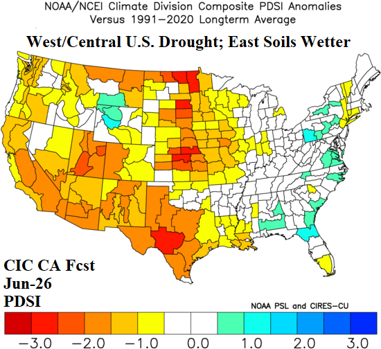
Although forecast models vary and consider possible improvement in U.S. soil moisture by late calendar spring, the Climate Impact Company constructed analog forecast of Palmer Drought Severity Index (PDSI) favors an expansive dry-to-drought pattern for both the West and Central U.S. Forecast confidence is near to above normal on weakening drought risk across the eastern third of the nation and strengthening drought across the West U.S. to Texas. However, forecast confidence is near to below average for the Central U.S. dry outlook.