News
03/11/2026, 5:37 am EDT

-PNA Pattern Rules U.S. Weather Pattern Next 15 Days

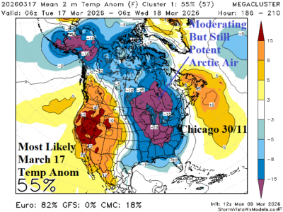
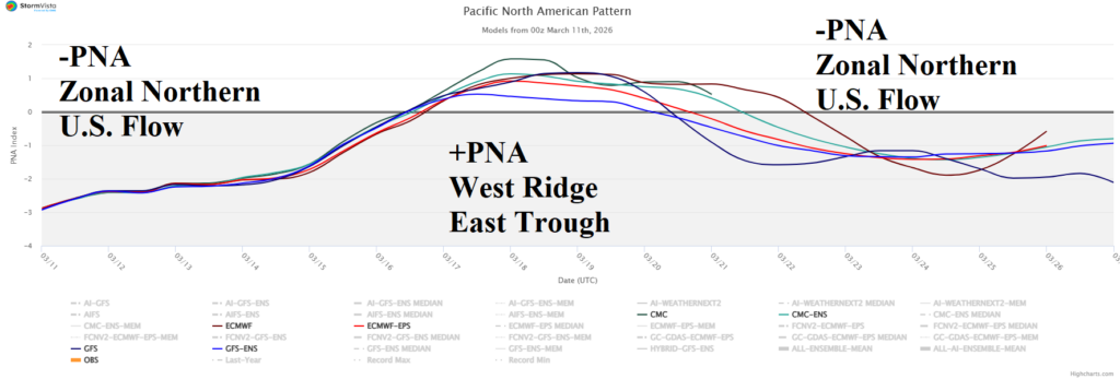
The pick of the day climate signal is the Pacific North America (PNA) regime. The 15-day outlook reveals ongoing negative phase into the weekend helping to fuel a Pineapple Express into Washington, shift to positive phase next week causing an amplified upper ridge to roast the Southwest U.S., and return to negative phase sustaining the cool/stormy North and warm/dry South split pattern.
03/11/2026, 4:44 am EDT

Dry Concerns West/Southwest Great Plains Emerging

A combination of zonal flow in the 1-5-day and 11-15-day period and titanic Southwest U.S. high pressure ridging in the 6-10-day period leaves the west and southwest Great Plains without rain and increasingly very warm in the latest ECM 15-day forecast. Texas to Oklahoma shift wetter in the 16-30-day period while the western Great Plains stay dry and very warm. U.S. hard red winter wheat becomes a hot spot for drought development.
03/09/2026, 5:02 pm EDT

12Z Models Become Convincing on Significant Cold East-central Next Week (and Hot Weather Southwest)

At midday, most forecast models agree that cross polar arctic air moves into North America and gains (anomalous) intensity flowing southward into the North-central/East-central U.S. March 16-17. At that time a small but potent polar vortex enhances the cold. This event may be related to the breakdown of a lengthy stratospheric warming event in the polar region.
03/09/2026, 2:04 pm EDT

Big El Nino in 2026 Possible Followed by Returning La Nina in 2027

The Climate Impact Company MAR-26 to FEB-28 ENSO phase forecast is based on a constructed analog utilizing upper ocean heat anomalies east of the Dateline, Nino34 SSTA, and southern oscillation index. The upper ocean heat in the eastern equatorial East Pacific became immense during February and is the leading indicator of El Nino risk ahead.