05/18/2025, 7:29 pm EDT
A map of the united states with a map of the weather AI-generated content may be incorrect.

Brief Review of the May 15-16 U.S. Severe Weather Event

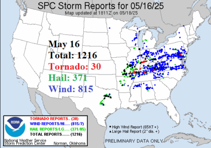
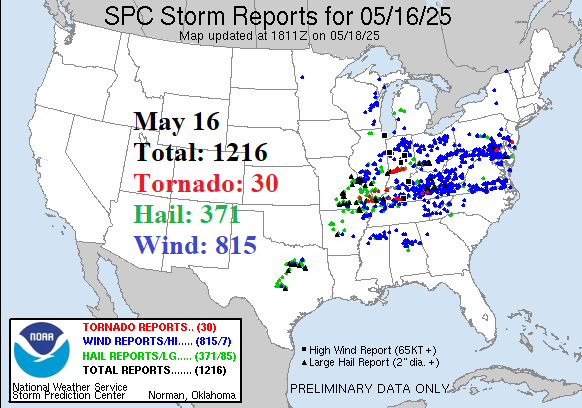
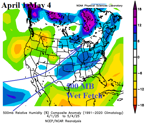
As a review, an exceptionally intense severe weather episode was observed late last week across the Upper Midwest, Midwest, and Mid-Atlantic States. On May 15 (Thursday), NOAA/SPC’s final count of severe weather reports is 657 including an unusually high amount of hail (274) plus 32 tornado reports. On May 16 (Friday), NOAA/SPC counted 1, 216 damage reports including a whopping 371 hail damage events and 815 wind damage reports.
05/14/2025, 8:14 am EDT
A map of the united states AI-generated content may be incorrect.

Checking U.S. and Europe/Western Russia Soil Moisture and Rainfall Pattern

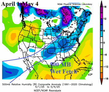
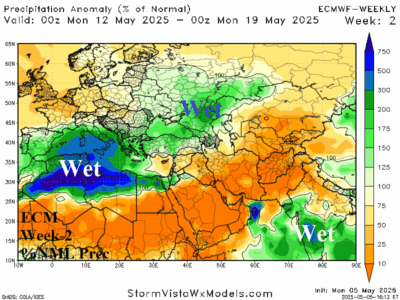
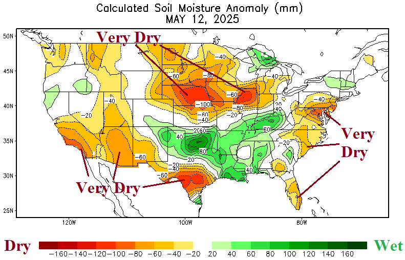
Large differences are regions of wet vs. dry soil across the Central and East U.S. are evident in the daily soil moisture anomaly analysis. The rainfall pattern is changeable and features significant events as organized drought risk heading toward meteorological summer is not weel-organized (except in the Southwest). The Southeast Europe to Southwest Russia drought receives relief from a showery pattern the next 2 weeks.
05/12/2025, 9:21 am EDT

Latest North Atlantic Basin SSTA Analysis

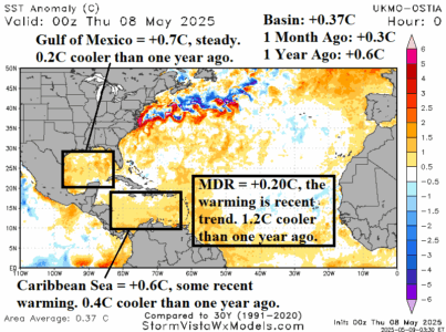
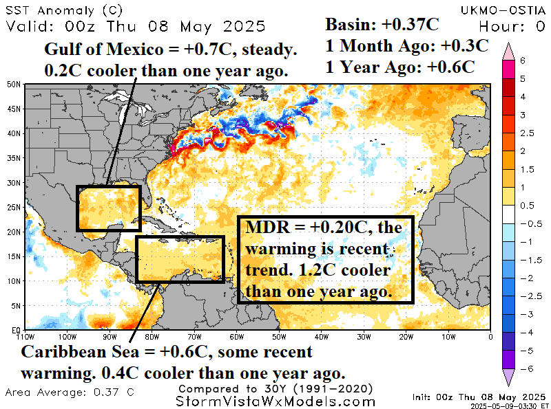
The official start of the North Atlantic basin tropical cyclone season is June 1st. During the active tropical cyclone season period of 2016-2024 when an average of 18-19 named storms have generated each year, the North Atlantic has averaged much warmer than normal and a likely catalyst to the active period. As mid-May approaches, the North Atlantic basin is marginally warm (+0.37C) and 0.23C cooler than 1 year ago.
05/12/2025, 9:16 am EDT
A map of the world AI-generated content may be incorrect.

A Look At Australia Bureau of Meteorology JUN/JUL/AUG 2025 Global SSTA Forecast

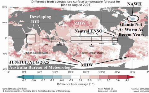
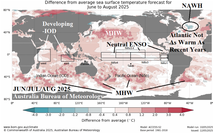
The latest JUN/JUL/AUG 2025 global SSTA forecast from the Australia Bureau of Meteorology reveals neutral ENSO with slight warming of the Nino SSTA regions, the beginnings of negative phase Indian Ocean dipole (-IOD), and a summertime North Atlantic basin which is warmer than normal although not nearly as warm as recent years.
05/12/2025, 5:17 am EDT
A graph of a state AI-generated content may be incorrect.

Early Season ERCOT Heatwave!

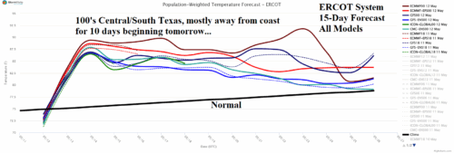
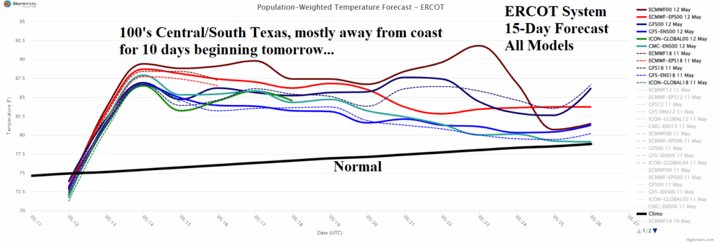
Subsidence on the back side of an East Coast trough causes the onset of an excessive hot weather pattern across Texas on Tuesday. The hottest day of an extended heatwave is Wednesday when southwest flow extending across Texas from the hot air source region across the Mexico drought area occurs. Widespread 100’s are likely on Wednesday. The hot southwest flow peaks Wednesday although likely remaining through the 10-day heat wave.
05/11/2025, 3:49 pm EDT
A graph of the number of the ocean AI-generated content may be incorrect.

Extended Range ENSO and IOD Forecast

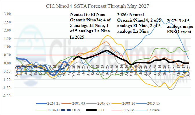
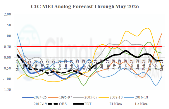
The oceanic ENSO projection favors the possibility of El Nino late this year while the atmospheric ENSO forecast is neutral phase. Dynamic models favor neutral ENSO phase although tilted toward La Nina returning if any deviation. Analog and dynamic models are, at least a little, disagreeable.
05/09/2025, 6:30 am EDT
A map of australia showing temperature AI-generated content may be incorrect.

The Power of Marine Heatwaves on Australia Climate

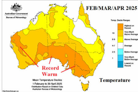
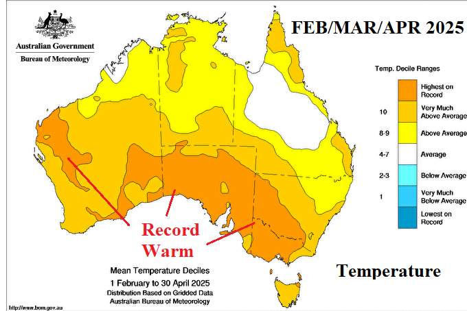
The primary culprit to the extreme heat observed across much of Australia during the past 3 months is the enhancing influence on subtropical upper-level high-pressure ridging stretching from southeast of New Zealand to Southern Australia by the presence of MHW’s.
05/08/2025, 3:10 pm EDT

The April 2025 U.S. Climate Pattern Waas Very Warm And On The Wet Side

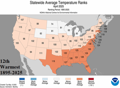
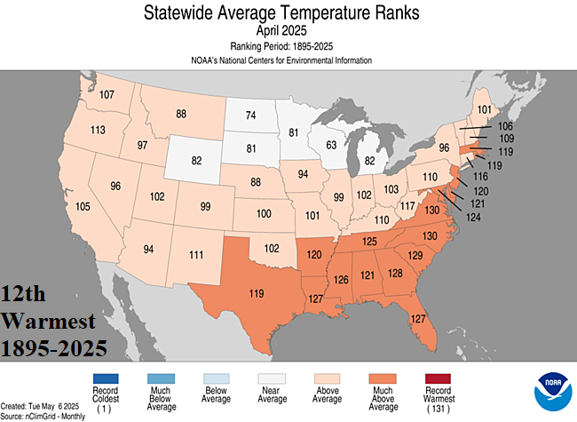
April 2025 was (nationally) the 12th warmest April on record. The entire Gulf region, Southeast U.S., and most of the East Coast averaged MUCH ABOVE normal. North Carolina and Virginia observed their 2nd warmest months of April in the 131-year period of record. Only the North-central U.S. States were not warmer than normal each averaging near normal for mid-spring.
05/08/2025, 3:05 pm EDT

Neutral ENSO Here To Stay

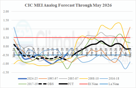
The Climate Impact Company constructed analog ENSO phase forecast valid through May 2026 yields oceanic (Nino34 SSTA) El Nino potential for later this year while the atmospheric (multivariate ENSO index) ENSO phase is neutral. Dynamic models mostly agree with neutral phase.
05/07/2025, 8:28 am EDT
A map of the weather AI-generated content may be incorrect.

Nino12 SSTA Vs. Brazil Rainfall Pattern

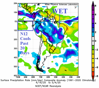
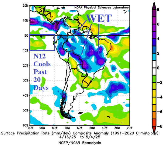
During mid-February to mid-April, the Nino12 SSTA region warmed to an unexpected +1C to +2C. During the 2-month period, the warm waters in this region contributed to a wet climate bias favoring northwest South America and eastward into North-central Brazil. As the Nino12 region cooled recently, wet weather shifted across Brazil.
05/06/2025, 5:06 am EDT
A map of different colors AI-generated content may be incorrect.

Southern Europe to Black Sea Region Heavy Rain Pattern Ahead

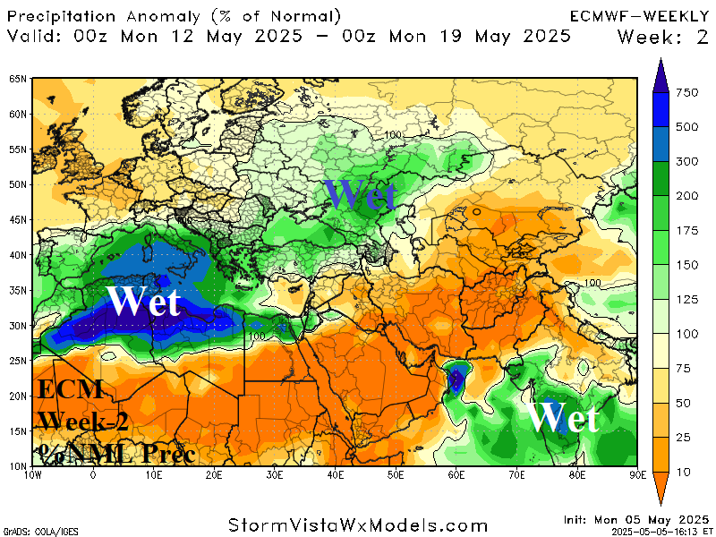
An amplifying upper-level low-pressure trough is forecast to settle over Europe through mid-May causing excessive rainfall from Southern Europe to Southwest Russia. Much of Europe turns much cooler due to the long-lasting storm. The Eastern Europe to Southwest Russia drought certainly receives some wet relief in this pattern. However, Western Europe is dry.