03/17/2024, 7:11 am EDT

Transient MJO Causal to Wetter Brazil/Australia/U.S. Midwest Pattern Ahead

The convection phase of the Madden Julian oscillation stretches across Maritime Continent and responsible for an active tropical cyclone pattern affecting Australia including Cateogry-2 Tropical Cyclone Megan on the North Coast. As the MJO shifts eastward and across the equatorial Pacific, the 5th such MJO surge since last September, a wetter pattern for Brazil and the Midwest U.S. generates in 8-14 days.
03/14/2024, 8:22 am EDT

Areas Susceptible for Drought during 2024 Warm Season

Based on a constructed analog which identifies: 1.) The evolution of a warming mid-latitude ocean during the past 10 years, 2.) An enhanced warming of the mid-latitude oceans during the past 5 years, and 3.) Decelerating El Nino to La Nina climate, a projection of 500 MB anomalies and attendant soil moisture conditions for Western Russia and the U.S. is provided.
03/13/2024, 3:51 am EDT

March 2024 Global Soil Moisture 3-Month Observation Trend and Forecast

During meteorological winter, the northern hemisphere received mostly a wetter soil moisture signature largely due to the influence of El Nino. In the U.S., most of the western half of the U.S. observed a wet soil moisture trend. Similarly, the U.S. East Coast trend was wetter particularly in the Northeast Corridor. The drier tendency in the Midwest continued.
03/13/2024, 3:49 am EDT

March 2024 Marine Heatwave/ENSO Discussion and Outlook

Using a different approach to analog ENSO phase for 2024, Climate Impact Company takes a look at the peak ocean heat east of the Dateline late in the year of the ongoing El Nino compared to the loss of upper ocean heat as El Nino weakens the following February.
03/11/2024, 9:22 am EDT

Searing Heat Beneath Subtropical Ridge in Brazil/Paraguay

The convection phase of the Madden Julian oscillation (MJO) is located over the Maritime Continent and increasing intensity. The influence on South America climate when MJO is in phase_4 is dryness across Brazil. The latest ECM ENS 15-day upper air forecast indicates the subtropical ridge is parked over Southeast Brazil, strongest over the next 15 days.
03/08/2024, 1:53 pm EST

Warmest U.S. Winter on Record!

The meteorological winter 2023-24 was the warmest on record (Fig. 3). This observation is made more impressive given that there was one arctic outbreak during mid-winter. Warmer than normal mid-latitude SSTA contributed to the already mild bias caused by El Nino. Record warmth was observed in 8 states: North Dakota, Minnesota, Iowa, Wisconsin, Michigan, New York, Vermont, and New Hampshire.
03/08/2024, 5:33 am EST

Record Warm Tropical South Atlantic Index/El Nino Inspired Hot/Dry Summer Most of Brazil

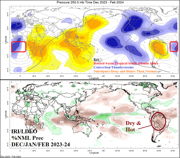
The tropical South Atlantic continues to observe record warm ocean temperatures. The influence on summer climate of the anomalous warmth was significant. Strong difluence in the upper atmosphere across the warm water zone represents anomalous convection (thunderstorm activity). To compensate for the rising air motion, an area of subsidence (sinking motion) over South America was observed during meteorological summer. The sensible weather result was drier and hotter than normal climate across much of Brazil. Of course, El Nino also enhanced this climate anomaly.
03/05/2024, 2:53 pm EST

Finding Climate Change in Northern Hemisphere Wintertime Upper Air Pattern During El Nino   

A comparison of northern hemisphere 500 MB height anomalies for DEC/JAN/FEB during the strongest 3 El Nino events of the past 30 years to the just-ended event yields several interesting observations. The general 500 MB anomaly pattern is remarkably consistent but notice how each year produces less and less bold upper trough signatures.
03/05/2024, 5:51 am EST

Soaking Wet Northeast U.S. Soils

Soaking wet soils are present across the Northwest U.S. and parts of the West Coast. However, our concern in this report is the emerging excessive soil moisture across the northern Mid-Atlantic region and the southern half of New England. The NOAA/WPC 7-day quantitative precipitation forecast (QPF) indicates prohibitive rainfall in the coastal Northeast Corridor region.