News
11/24/2023, 12:58 pm EST

Hot Spots: East Australia Rain and Europe Chill

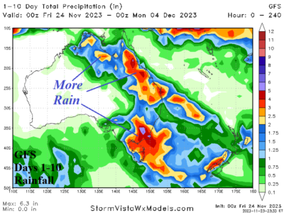
Satellite view reveals a persistent low-pressure trough extending northward from low pressure off the Southeast Australia Coast maintains wet weather in East Australia with hefty amount continuing. The latest 10-day outlook by GFS stays very wet in the East. There are some signs that the unexpected wet weather regime may ease after 10 days.
11/24/2023, 12:56 pm EST

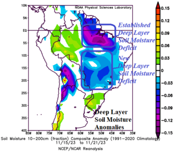
Deep Layer Soil Moisture Anomalies Drying…Central Brazil Drought Strengthening

Deep layer soil moisture anomalies are trending drier in Central/Southwest Brazil as drought potential in this region increases. The already established deep layer soil moisture dryness in North Brazil persists. The soil moisture dry trend is propelled by anomalous heat so far in November across Brazil. A drier than normal rainfall pattern continues over Northern Brazil and has increased near and east of Bolivia eastward to the Brazil East Coast.
11/21/2023, 2:37 pm EST

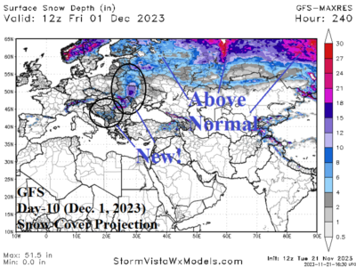
Early Winter Chill (and Snow) Ahead for Europe

After a vigorous windstorm on Thursday a colder regime settles over Europe and eventually most associated precipitation is snow. Eastern Europe to Interior Southeast Europe has snow on the ground by late month helping to enhance the chilly pattern. The week 2-4 forecast projects milder North Atlantic maritime flow in the extended range to scour away the chill.
11/21/2023, 9:51 am EST

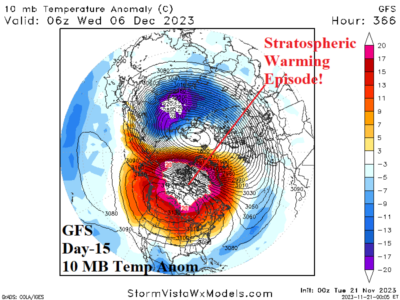
Stratospheric Warming Appears in 15 Days

At the surface, forecast models are very warm across the U.S. HOWEVER, trouble may be brewing in the upper atmosphere. The ECM ENS indicates a stratospheric warming event taking place over northwestern North America while GFS has this event with higher amplitude centered over Canada.