07/19/2022, 4:55 am EDT

Africa ITCZ Leads to Europe Heatwave

Typical of Europe heatwaves, extreme heat from the African Desert is propelled northward by the subtropical ridge this time inspired by the combination of a strong Africa ITCZ and an offshore Southwest Europe low-pressure area. The southerly flow ahead of the low-pressure area guided an amplified subtropical ridge into Western Europe to deliver historic heat the past few days.
07/17/2022, 12:22 pm EDT

Effects on Climate of Warming Reginal SSTA

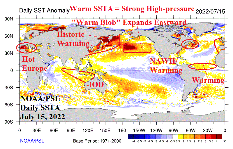
As northern hemisphere mid-summer approaches, mid-latitude ocean waters are warming to much above normal levels off the East Asia Coast, north and northeast of Hawaii and east of the Northeast U.S. plus the Mediterranean Sea. ECMWF projects the warming to continue and intensify. Large areas of very warm sea surface temperature anomalies (SSTA) are well-correlated with stronger-than-normal high-pressure aloft which increases risk of drought and anomalous heat in the affected areas.
07/14/2022, 9:24 am EDT

Tropical Upper Tropospheric Trough Forming?

A well-defined upper-level LOW has formed over Cuba and is established over most levels of the atmosphere in that zone. An upper-level LOW in this region will be difficult to remove. If the upper-level LOW elongates southwestward with time the configuration of this feature takes-on a trough-like pattern rather than a closed low as we have now.
07/14/2022, 8:53 am EDT

July 22-28, 2022 Forecast is Second Hottest in U.S. of Past 20 Years

The Climate Impact Company U.S. CDD projection for the last week of July is 103 which is second hottest to 105 CDD observed in 2016 (using NOAA CDD data). The last week of July in 2011 is a close 3rd hottest from the last 20 years and along with 2016 and the 2022 projection the only last week of July to produce over 100 CDD.
07/13/2022, 12:19 pm EDT

GFS ENS Warm Forecast Bias in the West U.S.

An extraordinary difference in temperature bias shown in 15-day forecasts from the past 30 days appears when comparing ECM ENS vs. GFS ENS. The ECM ENS is reasonable with patchy relatively small temperature bias slightly favoring the warm side. However, the GFS ENS is boldly too warm across the Southwest and Interior West U.S.
07/12/2022, 8:01 am EDT

Flash Drought Central U.S. Ahead

Large regions of deep-layer soil moisture deficits are caused by long-term (usually 9 months or more) precipitation shortages. In the U.S. and generally east of the Continental Divide, presence of large areas of deep-layer soil moisture deficits can foreshadow flash drought risk areas.
07/11/2022, 8:19 pm EDT

U.S. June and Quarter 2 of 2022 U.S. Climate Rankings

The June 2022 national temperature ranking was 15th warmest (of 128 years). The southern tier of the U.S. ranked in the MUCH ABOVE normal category with Texas close to an all-time record. The June 2022 national precipitation pattern was 12th driest on record and featured a wet pattern in the West (wettest June on record for Oregon) while the Central and East U.S. were very dry including the 2nd driest June on record in North Carolina.
07/11/2022, 7:53 am EDT

Heavy Rains across the Northwest/North Gulf of Mexico.

Gathering storm clouds in the northwest Gulf of Mexico leads to a week of heavy rain featuring risk of >10 in. on the southeast Louisiana coast. Low-pressure is offshore and over the warm Gulf of Mexico therefore monitoring for a possible tropical system later this week is required.