News
04/23/2020, 4:38 pm EDT

Heavy Rain Set-up for the Midwest/Northeast U.S. Corridor

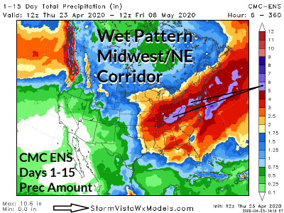
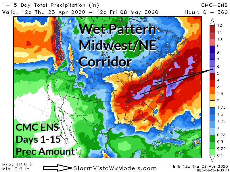
Forecast trend of many operational forecast models is too lift the excessive rainfall/flash flood and severe weather pattern established across the Gulf region farther north to the Midwest U.S. extending to the Northeast Corridor to finish April and begin the month of May.
04/19/2020, 9:49 am EDT

Unique: Very Warm Gulf of Mexico and Tropical North Atlantic Ahead of the 2020 Tropical Cyclone Season

Unique to 2020, the pre-tropical cyclone season sea surface temperature anomalies (SSTA) are unusually warm in both the Gulf of Mexico and the tropical/subtropical North Atlantic basin in-between the eastern Caribbean Sea and northwest coast of Africa. Implied is abundant (unprecedented?) upper ocean/surface heating to cause passing tropical cyclones to intensify dramatically (assuming the proper upper air patterns).
04/14/2020, 12:50 pm EDT

Indian Ocean Dipole Outlook: Possible Negative Phase by July

An emerging negative Indian Ocean Dipole for JUL/AUG is (now) forecast by the Australia Bureau of Meteorology. -IOD favors a wetter winter climate pattern across Australia likely easing any remaining drought across the continent.