News
11/17/2025, 4:34 am EST
A graph of different colored lines AI-generated content may be incorrect.

Chicago and Boston Winter 2025-26 Snowfall Forecast

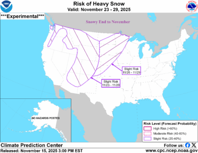
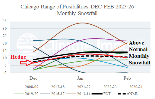
The projected SSTA regime and SSW risk are found in 7 different analog years in the modern climate era (since the mid-to-late 1990’s). Each year has an assigned statistical weight based on the strength of the analog. The consensus of the analog years yields an above normal snowfall each month of meteorological winter 2025-26 in Chicago and Boston (except for February).
11/17/2025, 4:30 am EST
A map of weather forecast AI-generated content may be incorrect.

Europe Outlook To Close November Stormy/Wet

The upper air pattern projected across Europe during the next 1-2 weeks features a deep upper-level low-pressure trough causing chilly weather for the next 10 days (at least) and excessive rainfall capable of producing flooding in parts of central, south, and southeast portions of Europe. Heavy snows are likely in the South-central Europe mountain areas, and the wet regime extends eastward to include Ukraine.
11/16/2025, 12:19 pm EST
A map of the united states with different weather conditions AI-generated content may be incorrect.

Snowy Last Week of November Northwest/North-central U.S.

Typical of a La Nina climate, the Northwest U.S./Southwest Canada to North-central U.S. are usually the first winter targets for cold and snow. The NOAA/CPC risk of heavy snow ALERT for the last week of November indicates heavy snow risk for the Continental Divide and North-central U.S. likely to sustain following cold.
11/16/2025, 12:17 pm EST
A map of the south america AI-generated content may be incorrect.

Anticipated Wetter Brazil Pattern Initiates in the 6-10-Day Period

A wet weather shift from Argentina and more recently central continent into Central/East Brazil initiates in the 6-10-day period according to the "most likely" mega-cluster ensemble. The wetter shift should remain in-place well through early meteorological summer 2025-26 while Argentina shifts drier.