News
05/24/2024, 4:43 am EDT

NOAA/NHC 2024 Hurricane Outlook

NOAA/NHC issues their most active seasonal forecast since outlooks began earlier this century. The active forecast follows a similar theme with previous outlooks issued by CSU, TSR U.K., and CIC. Given the number of major hurricanes forecast for this year, monitoring the 86/87F SST (where major hurricanes are most likely) becomes extremely important!
05/22/2024, 10:35 am EDT

More Severe Weather Ahead for U.S. Crop Areas

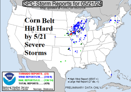
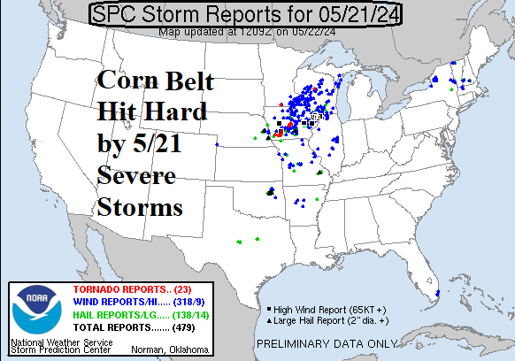
A major severe weather event struck the U.S. Corn Belt yesterday with nearly 500 severe weather damage reports collected by NOAA/SPC including 23 tornado reports. Central Iowa to southwestern Wisconsin were the hardest hit. Flooding from excessive rainfall also occurred in this stretch.
05/20/2024, 2:23 pm EDT

Record Warm Sectors of the North Atlantic Basin Getting Warmer

The daily North Atlantic basin sea surface temperature anomaly (SSTA) is +0.94C and implies the Atlantic multi-decadal oscillation (AMO) is similar and therefore easily a record warm value for May. The North Atlantic basin has warmed 0.23C during the past 7 days. A primary contributor is the tropical North Atlantic (TNA) index located across the main development region (MDR) for hurricanes. The daily TNA index is +1.46C maintaining the record warm signature in this part of the outer tropical North Atlantic basin.