News
05/22/2023, 12:22 pm EDT

Transient MJO, Strong -SOI, and Very Warm Subsurface…El Nino Onset Ahead!

All the ingredients are there, transient intense Madden Julian oscillation (MJO) to shut down trade winds, steady and intensifying negative southern oscillation index (SOI) to produce an El Nino climate, and exceptionally warm subsurface temperatures across the equatorial Pacific to fuel a developing warm ENSO.
05/22/2023, 6:09 am EDT

North Atlantic Warm Hole Trough Cooling East U.S. Departs Temporarily

What is the North Atlantic warm hole (NAWH)? Since 2013, the NAWH pattern has strengthened due to accelerated presence of freshwater snow and ice melt from Northeast Canada and Greenland deposited into the Labrador Sea and eastward/southward most noticeable during MAY/JUN but generally present most of the year. During the past 10 years, the cool ocean waters have caused a cooling of the middle troposphere where a semi-permanent upper trough has generated. During the past 30 days, the trough has amplified off the Southeast Canada Coast and extended into the East U.S. bringing a cool late spring.
05/21/2023, 12:51 pm EDT

Updating The U.S. Population Weight CDD Forecast for Summer 2023

The MAY-SEP 2023 U.S. population weight CDD forecast is adjusted. The outlook trends slightly warmer. Note that the outlook is consistently warmer than the 30-year climatology but not as hot as the majority of the last 3 years through July followed by AUG/SEP forecasts which are similar.
05/21/2023, 8:57 am EDT

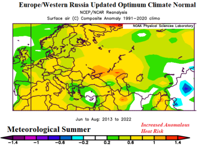
A Look at Summer U.S. and EU/RU New Optimum Climate Normal

Applied to all climate forecasts is recent historical patterns due to their significant difference from a standard 30-year climatology and driven (mostly) by accelerated ocean surface warming of recent years. Specifically, emergence of a semi-permanent marine heat wave (MHW) in the northeast quadrant of the North Pacific Ocean and similar but opposite (cool) sea surface temperature anomaly regime south of Greenland known as the North Atlantic warm hole (NAWH).