News
07/13/2020, 9:31 am EDT

The La Nina In 2020 Forecast Is In Jeopardy

The subsurface equatorial Pacific to the east of the Dateline is losing a moderate-strength cool signature which developed in May and signaled La Nina ahead. In recent weeks the cool anomaly has nearly disappeared. Subsurface support for La Nina evolution will need to rebuild.
07/12/2020, 11:26 am EDT

Why The Tropics Should Become More Active Later July

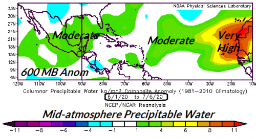
Research (AMS/Journal of Climate 2/15/18) has shown one of the key predictors of increased North Atlantic tropical cyclone activity since 1995 is the increased mid-atmospheric relative humidity at the onset of tropical cyclone season. Right now mid-atmospheric RH is buoyant in the Bahamas and especially the main development region for North Atlantic hurricanes to the east of the Caribbean Sea. Once the Saharan dust clouds fade (possibly beginning later this week) an uptick in deep tropics systems should emerge.
07/10/2020, 5:33 pm EDT

A Key Predictor of Seasonal Tropical Cyclone Activity

A key climate diagnostic identifying tropical cyclone potential across the tropical/subtropical North Atlantic basin at early onset of the season is the relative humidity or available moisture in the middle atmosphere. Above to much above normal available moisture, common during the past 25 years of seasonal uptick in North Atlantic activity signals above normal activity ahead. The early 2020 season available moisture is buoyant across the Gulf of Mexico and outer tropical basin signaling an active season ahead!