News
03/31/2025, 1:07 pm EDT

If Warm Nino12 SSTA Region Persists, Hurricane Activity Suppressed

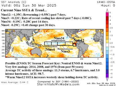
Of potential influence on the 2025 North Atlantic tropical cyclone season is the ongoing very warm Nino12 SSTA off the northwest coast of South America while the Nino34 SSTA, where oceanic ENSO phase is measured, has recently shifted from La Nina to neutral ENSO although waters in this region have re-cooled slightly during the past 2 weeks. The persistent unusual warming of waters off the northwest coast of South America while the remainder of the equatorial East Pacific observed near normal SSTA began in early February.
03/31/2025, 8:02 am EDT

High Impact Weather Week in the U.S.

Dangerous flooding is likely in the East-central U.S. this week focused on WED-FRI due to a day-after-day severe weather and excessive rainfall in the same area. The area affected is Dallas to Oklahoma City northeastward to St. Louis and Memphis and into the Ohio Valley. After the heavy rain, unseasonably chilly air arrives.
03/31/2025, 4:54 am EDT

Unusually Chilly Weather Ahead for East Europe/West Russia

Expect unseasonably chilly air to emerge in the 8-14-day period with coolest anomalies across East Europe and West Russia. Threshold temperatures include <32F across much of central and east portions of Europe and west sections of Russia in the 6-10-day period.
03/30/2025, 11:55 am EDT

Adding Cold Risk to Midwest U.S. (with Rainy Periods) Hindering Crop Planting

Of added importance to the forecast is cold weather. Focused primarily on the 8-14-day period, a chilly early April is indicated especially for the Eastern Corn Belt. The risk of <32F extends to the Tennessee Valley and across the Midwest U.S. with widespread 20’s reaching the Ohio Valley in the 11-15-day period.