News
02/06/2025, 1:53 pm EST

Is There Sudden Stratospheric Warming Ahead in Early March?

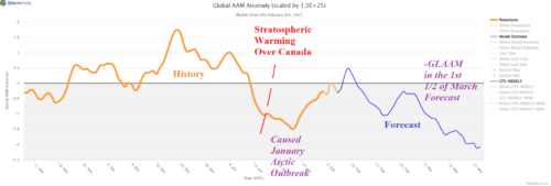
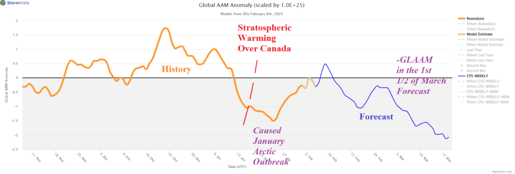
Utilizing CFS V2 extended range forecasts of the stratosphere there is not an obvious sign of an emerging sudden stratospheric warming (SSW) event during late FEB/early MAR. The ECM forecast is not available. HOWEVER, a major slowdown of the global atmospheric angular momentum (GLAAM) is in the forecast through mid-March. When -GLAAM occurs, the mid-latitude upper-level pattern has the tendency to produce amplified low-pressure troughs.
02/06/2025, 4:01 am EST

Excessive Heat/Dryness Warning Argentina!

A titanic high-pressure area extending eastward from a marine heat wave west of South America causes extreme heat over the next 5-7 days in Argentina coupled with dryness likely to accelerate drought conditions into late summer.
02/05/2025, 12:57 pm EST

Tracking Winter Weather Events in the East

A large area of snow is forecast to the north of a slowly developing low pressure system, most intense off the Northeast Coast, this weekend. The NBM model forecasts 4-8 in. of snow in the Midwest which looks a bit high, and a more aggressive snowfall forecast, for New England, especially near the coast as the storm strengthens offshore early Sunday. There is a freezing rain/ice accretion risk across a large area most likely causing impacts over west-central Pennsylvania.
02/04/2025, 5:32 am EST

Impactful Winter Storms Ahead for the Central and Northeast U.S.

Although extended range U.S. forecasts trend milder overnight, there is a caveat for the Midwest to Northeast U.S. Corridor. During next week’s cold, the North and East U.S. storm track turns snowy. Consequently, as the U.S. enters the extended range, snow on the ground could allow chilly air to linger, especially in the Northeast.