News
11/05/2024, 4:41 am EST

The Ridiculously Resilient Ridge Pattern

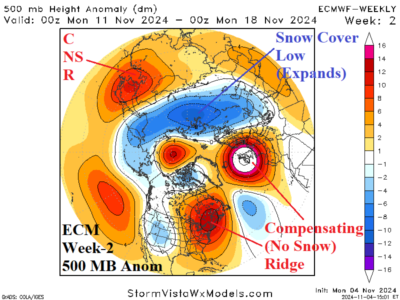
An expanding Northern Eurasia snow cover cools the atmosphere aloft and forces a broad low-pressure trough during mid-November. To compensate, a ridiculously resilient ridge (RRR) stays intact across eastern North America and Western Europe enhanced by lack of snow cover and a marine heat wave (MHW) west of Europe.
11/03/2024, 1:33 pm EST

Tropical Cyclone Threatens Gulf of Mexico Later This Week

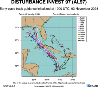
Tropical Disturbance 97L located in the south-central Caribbean Sea is forecast to become a tropical storm traveling northwestward across Western Cuba Wednesday with a low confidence 4-5-day forecast track into the northeast Gulf of Mexico. Tropical cyclone model intensity forecasts indicate tropical storm intensity and for the moment doubt hurricane risk. A northwestward traveling tropical cyclone into the Gulf of Mexico is rare.
11/03/2024, 11:10 am EST

Brazil Forecasts Have Been Too Wet

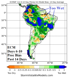
East-central Brazil and North-central Argentina drought has eased. Forecasts have been wet the past 2+ weeks. However, the wet forecasts for the 6-10-day period are too wet, especially using the ECM. Based on rainfall bias skill scores, the GFS is the better forecast model to project the 14-day rainfall outlook.
11/01/2024, 8:30 am EDT

Forecasting ENSO Phase is Extremely Difficult

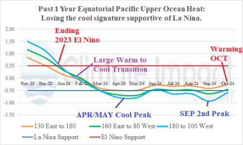
The Australia Bureau of Meteorology adds the following statement to their ENSO outlooks: “Global SSTs remain at near record levels, with temperatures since July being just short of the record temperatures observed during 2023, yet above all other years since observations began in 1854. The sustained nature of this significant global ocean heat suggests that climate indicators such as ENSO and IOD may not behave or evolve as they have in the past.”