News
10/27/2024, 7:06 am EDT

Much Cooler Europe early November Thanks to Negative Scandinavia Index Regime

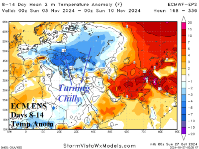
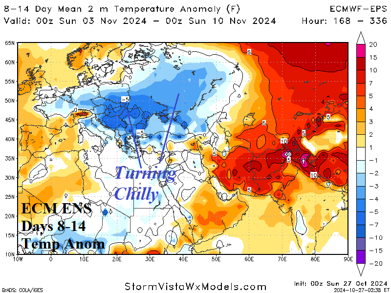
In Europe, an evolving sharp negative phase of the Scandinavia index in early November indicates an amplified upper ridge over Northwest Eurasia and a compensating trough into Southeast Europe. The upper trough brings stormy and much cooler weather to Europe to Southwest Russia in the medium range.
10/27/2024, 6:56 am EDT

Brazil (and Argentina) Rains Continue

During October, Northwest Argentina turned very wet. During the past week, the wet pattern in Argentina shifted slightly southward and remains intense. Meanwhile, a separate wet weather pattern has emerged during the past week in Brazil featuring drought suppressing heavy rains from East-central Brazil eastward to the coast.
10/26/2024, 10:19 am EDT

Early November Tropical Cyclone Risk Update

After a series of GFS model runs indicating an East U.S. Coast tropical cyclone risk in early November, possibly disrupting voting day, forecast models are now in agreement the tropical system is likely to stay away from U.S. Atlantic Seaboard. The new forecast creates another problem, a heavy rainfall episode in early November centered on Texas and the southern Great Plains.
10/25/2024, 11:42 am EDT

Australia Heatwave Ahead!

A major heat wave is emerging in the medium range across Australia. A high-pressure ridge amplifies across Western Australia into early next week causing the onset of the hot weather pattern. East-coastal Australia is cool into early next week. However, the upper ridge is progressive, and the heat wave advances across Australia in the 6-10-day period according to the latest AI model, EXCARTA.