News
08/18/2024, 9:39 am EDT

Fast Trade Winds Preventing Very Active North Atlantic TC Regime

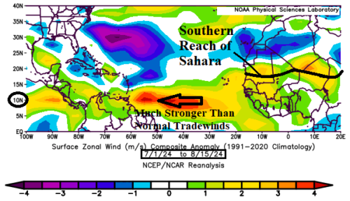
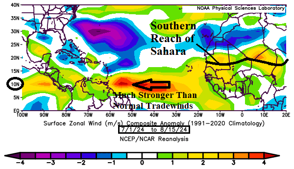
Faster than normal trade winds are normally associated with a temperature inversion usually around 850 MB (about 1,500 meters). The temperature inversion prevents vertical motion enabling convective cloud formation associated with developing tropical disturbances. Since July 1st, trade winds have been much faster than normal across the North Atlantic tropics.
08/15/2024, 10:32 am EDT

NOAA Long-lead Climate Forecasts; CIC Comparisons and SEP/OCT/NOV High Impact Climate

A comparison between the Climate Impact Company constructed analog and NOAA/CPC probabilistic forecast for meteorological winter 2023-24 is, not surprisingly, reasonably similar. NOAA/CPC expands drought in the West-central/Central U.S. this autumn season. The Southeast/East Coast are at risk of tropical cyclone strikes the next couple months.
08/15/2024, 5:05 am EDT

North America Winter 2024-25 Can Expect a “Polar Vortex” in February

Based on a constructed analog combining optimum climate normal and ENSO analog years the upper air pattern for North America for each month of meteorological winter 2024-25 is projected. Revealed is low risk of a “polar vortex” pattern during December or January. However, a broad polar vortex pattern is forecast across Southern Canada during February.
08/14/2024, 11:47 am EDT

Dramatic Uptick in Tropical Activity Late August into Mid-September

The North Atlantic basin is becoming ripe for a sudden uptick in tropical cyclone activity after Ernesto. ECMWF indicates many ALERTS for tropical cyclone development for later in August to mid-September. During this time, several to as many as 5 hurricanes may emerge.