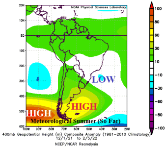
An unusually hostile climate pattern has emerged in South America during the 2021-22 warm season. Anomalous heat and dryness have propelled a drought in Paraguay to Southeast Brazil to Northern Argentina while excessive rains have plagued Brazil. While La Nina has contributed to this pattern, the more likely specific catalyst is the semi-permanent upper-level low-pressure trough southeast of Brazil extending northwestward into Brazil to cause convective rains compensated for by subsidence on the back side of that rainfall and centered on Paraguay and Argentina to cause just-the-opposite climate pattern – dryness and heat to accelerate drought.