News
01/05/2025, 4:08 pm EST

Ongoing Southeast Australia Bushfires Receive Some Short-term (Only) Minor (Rain) Relief

The Southeast Coastal Region of Australia was very dry in both DEC-24 and OCT/NOV/DEC-24. Otherwise, precipitation has averaged above normal to excessively wet across many parts of the continent during that time. Helping to aggravate the Coastal Southeast Drought is anomalous warmth during Q4/2024 which became somewhat hotter than normal for East-central and Southeast Australia during DEC-24. The anomalous heat accelerated the drying of soil. Consequently, a massive bushfire regime has developed from Victoria to New South Wales.
01/05/2025, 3:52 pm EST

The Ongoing Heavy Snow and Ice Storm for Central and East U.S.

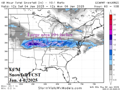
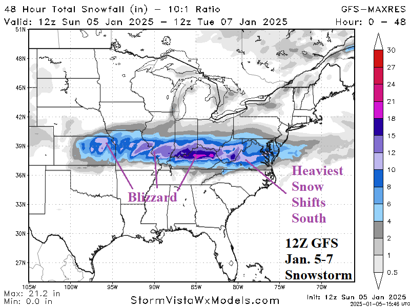
Heavy snow, including blizzard conditions in the Central U.S., are shifting eastward. Heavy snow shifts east of the Appalachians late tonight. A large swath of freezing rain will extend eastward across Kentucky tonight. Axis of the heavy snow in the Mid-Atlantic region shifts slightly south and now includes Washington, DC to Central Virginia. Cold winds follow the storm causing blowing and drifting.
01/02/2025, 7:12 pm EST

Europe Week 2-4 Outlook Revised Sharply Milder (and Drier)

Upper ridge pattern evolves across Europe mid-to-late January and supports a warmer reversal in the previous chilly forecast. Additionally, due to the high pressure a somewhat drier than normal climate is forecast for January as storminess shifts to West-central Russia.
01/02/2025, 4:58 am EST

Heavy Snow and Ice Storm Ahead for Lower Midwest States

A large area of snow develops across the central Great Plains Saturday night extending to the Missouri Valley Sunday morning and across the southern half of the Ohio Valley on Sunday. Snow extends to the Mid-Atlantic States Sunday night and Monday. A large swath of 6-12 in. of snow is likely with high spots in the 12-18 in. range in Missouri.