News
10/28/2022, 8:49 am EDT

Climate Influences on South America Summer Climate

Look at the warm SSTA forecast across the subtropical southern hemisphere valid for mid-to-late summer. The projection by the IMME model is likely the warmest signature on record. Above and downwind warm SSTA zones, upper-level high-pressure ridging in the subtropics is generated.
10/26/2022, 5:00 am EDT

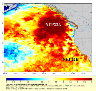
Updating The North Pacific “Warm Blob” and Explaining Optimum Climate Normal

According to NOAA/SFSC the 2022 Northeast Pacific "warm blob" (NEP22A) has reached a sufficient intensity and aerial coverage making NEP22A the 4th most intense in the 40-year record. This feature, semi-permanent since 2014, has been well-correlated to a persistent upper-level pattern in the northern hemisphere featuring a drought-enhancing western North America drought and presence of a "polar vortex" sometimes capable of delivering extreme cold to the U.S. during winter.
10/25/2022, 4:26 am EDT

Persistent Wet Southeast Brazil Upper Trough Becomes Migratory…Wetter Northeast Brazil

Wet to very wet climate has dominated southwest and interior southeast Brazil during the past 90 days. The culprit has been a semi-permanent (wet) upper-level low-pressure trough over Southeast Brazil. In Novmber, the trough becomes more migratory and forces the wetter climate into Northeast Brazil while Southern Brazil and Argentina have a tendency for drier than normal climate.
10/24/2022, 4:46 am EDT

Very Dry Pattern Forecast to Return to Much of Europe

Over-the-weekend all forecast models indicated a harsh dry trend across much of Europe through the next 15 days including the ECM ENS. The issue is a stalled wet upper trough off Western Europe compensated for by a broad upper ridge pattern in Europe.