News
12/02/2024, 4:25 pm EST

Cold Stratosphere Just-after Mid-month in Polar Region

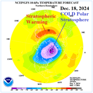
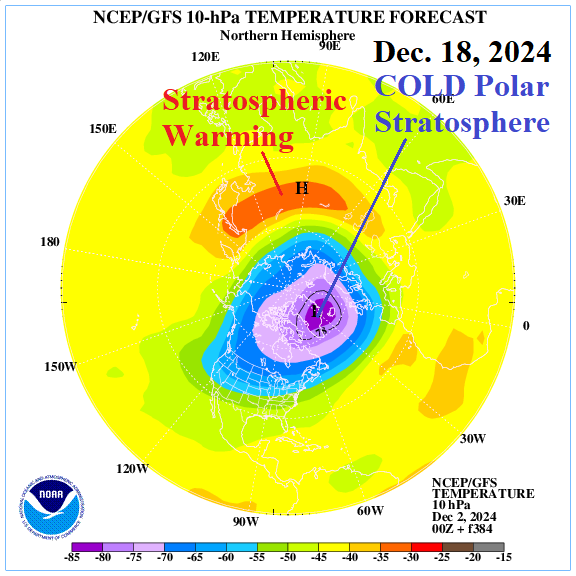
In 16 days (Dec. 18) the GFS indicates a very cold stratosphere in the polar region. A classic stratospheric warming event causing mid-latitude arctic air outbreaks would be just the opposite of the forecast. There is some stratospheric warming across Asia in 16 days possibly inspiring some arctic air across parts of Russia to Tibet.
12/02/2024, 8:00 am EST

Potential Regenerating Cold in the Northeast U.S. Early January

Both GFS and ECM regenerate a cold upper trough in the Northeast U.S. to Quebec sector as the middle third of January approaches. The forecast explains why a surge in U.S. heating demand is projected by CFS V2 and ECM for the week of Jan. 3-9.
12/01/2024, 11:14 am EST

Colder/Snowier Forecast Change for Europe Beginning Next Weekend

A colder pattern across West/Central Europe emerges in the medium range according to ECM. During the colder transition, a large area of precipitation centered on Central Europe is indicated. As the colder weather strengthens, precipitation is over to mostly snow for Central to Southeast Europe and the Southern Mountains.
12/01/2024, 8:13 am EST

Warm Great Lakes + Arctic Air = Immense Lake-effect Snows!

The Great Lakes are exceptionally warm, averaging in the upper 40’s to low 50’s and with a steady arctic air mass crossing over the lakes an immense lake-effect snowfall event is underway. The 1-5-day GFS snowfall forecast indicates an extreme amount from Western Michigan to New York with widening southern extent due to Alberta Clipper storms in the 6-10-day period.