News
09/23/2024, 1:49 pm EDT

The Much Warmer Than Normal Eastern Gulf of Mexico

During recent years, the (certain) catalyst to a category-4/category-5 major hurricane has been travel of the tropical cyclone across 31C/87F (or warmer) SST. Right now, the SST for the most likely path of Helene is 30C/86F certainly sufficient to fuel a category-3 major hurricane. The SST across the northeast Gulf of Mexico is a scary 0.75C to 1.75C warmer than normal. 
09/22/2024, 1:00 pm EDT

MJO Leads to Spiking GLAAM/GWO! (Associated With North Atlantic TC’s)

An eastward shift of the convection phase of the Madden Julian oscillation (MJO) is forecast by all operational models. The MJO was semi-permanent in the tropical Indian Ocean to Maritime Continent since early August. The eastern shift is across the tropical East Pacific and Atlantic to West Africa through the next 2-3 weeks activating tropical cyclone activity in each ocean basin.
09/22/2024, 8:39 am EDT

GFS, ECM, and AIFS Opinions on a Gulf Tropical Cyclone

A tropical cyclone is forecast to generate in the western Caribbean Sea in a couple days and then turn northwest and north becoming a hurricane in the eastern Gulf of Mexico heading toward the Big Bend Area in northwest Florida. GFS, ECM, and AIFS are in reasonable agreement with landfall but vary widely with where the storm tracks once inland.
09/21/2024, 9:03 am EDT

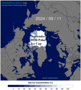
The Likelihood of Abundant Northern Hemisphere Early Season Snow Cover

During September 2024 the sea and ice concentration within the polar ice cap is 4th lowest in the 1978-2024 climatology. By comparison, the polar ice cap is considerably smaller than typical of 40+ years ago. The modern-day constricted polar ice cap has contributed to a recent trend of above normal snow cover developing early in the northern hemisphere cold season.