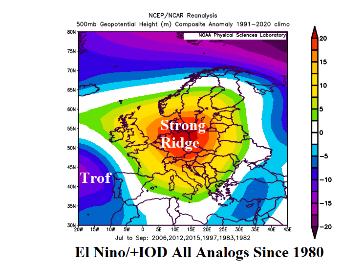
Strong El Nino/Positive Phase Indian Ocean Dipole Correlate to Europe Summer Drought
03/15/2023, 8:30 am EDTTutorial: Using Mega-cluster Ensemble to Project Great Plains Precipitation
04/07/2023, 9:16 am EDT
Fig: 1: Northeast Pacific SSTA analysis identifying the presence and location of the NEP22A marine heat wave.
Discussion: The NOAA Integrated Ecosystem Assessment (IEA) has updated the status of marine heatwave (MHW) NEP22A in the Northeast Pacific. According to the Mar. 20th assessment, NEP22A has persisted for 15 months and did not disperse during JAN/FEB/MAR as previous MHW’s have shown. NEP22A is the 2nd longest duration and 4th largest in aerial coverage MHW since 1982. MHW NEP22A peaked in August 2022 and has shifted west since as the cool phase of the Pacific decadal oscillation (-PDO) became more dominant cooling the waters off the Western North America Coast. According to IEA, NEP22A is budging eastward again (Fig. 1). IEA notes that NEP22A is likely to persist through summer of 2023. Global SSTA forecasts indicate intensification of NEP22A and further eastward drift (Fig. 2) although unable to reach the North America West Coast. Global SSTA forecasts generally indicate a strong El Nino developing during summer 2023 possibly similar in strength to the 2015-16 El Nino. The 2015-16 El Nino followed the eastward shift of a MHW generated in the Northeast Pacific in late 2013 reaching the West Coast of North America in 2014-15 and followed by the impressive 2015-16 El Nino. NEP22A not reaching the West Coast of North America during summer of 2023 suggests that the strong El Nino in the East Pacific forecast by many dynamic models may be too strong.

Fig: 2: ECMWF global SSTA forecast for July 2023 indicates evolution of a strong El Nino while MHW NEP22A stays off the North America West Coast.
Following the evolution of MHW’s in the Northeast Pacific during late 2013 and through the past decade has shown a significant influence on the upper air pattern affecting North America climate. The 2014-22 500 MB anomaly analysis yields a semi-permanent highly amplified upper-level high-pressure ridge in the Northeast Pacific (Fig. 3) which occasionally shifts east when MHW’s approach the North America West Coast (Fig. 4). The eastward migration of the MHW-inspired upper ridge was causal to long-term drought observed in Western North America, most notably in California. During Q1/2023, the MHW shifted westward allowing waters off the West Coast to cool characteristic of cool phase Pacific decadal oscillation (-PDO). The MHW-driven upper-level high-pressure ridge also shifted westward compensated for by a high amplitude upper-level low-pressure trough which brought heavy precipitation and cold western to the West U.S. during Q1/2023 (Fig. 5).


Fig: 3-5: The Northeast Pacific tendency for presence of MHW’s during the past decade is well-correlated to an upper-level high-pressure ridge (top left) which shifts eastward when MHW’s reach the North America West Coast and westward when MHW’s shift to waters north of Hawaii.